Traces of the Border of the Roman Empire
In many areas of Germany, you come across traces of the Romans again and again. Be it a fort, a column, a road or the remains of a very long border. While working on the book “Deutschland – eine Reise durch die Zeit” (Germany – a journey through time) about places and landscapes of German history, I once again dealt with the history of the Limes and began to photograph the subject of the Limes bit by bit.
This developed into this series about the border of the Roman Empire in what was then Germania, which still runs through four German states today. The history of the Limes is as complex as its length:
The expansion of the Upper Germanic-Raetian Limes was preceded by a long history of conquests – the borderline existed from about 100 to around 260 A.D. The Limes is named after the two Roman provinces of Upper Germania (Germania superior) and Raetia (Raetia).
In the north, the border began at Rheinbrohl on the Rhine and continued through the heights of the Westerwald and Taunus through the Wetterau in Hesse, where the Limes made a wide arc south to the Main. There, the border ran along the river for a few kilometres before, from Miltenberg, it ran as if drawn with a ruler through forests and over hills to Lorch. At the Limes bend near the border of the then provinces of Upper Germania and Raetia, the Limes once again ran dead straight eastwards, enclosed the fertile Nördlinger Ries in a wide arc and ended at Eining southwest of Regensburg on the Danube.
The 550 km long Limes is the second longest archaeological monument after the Great Wall of China, if one likes to use superlative comparisons.
Even though the Limes with its watchtowers and palisade is reminiscent of the seemingly insurmountable German-German border, the Roman outer border was an open border and served to control trade, levy customs duties and regulate border crossings from Germania into the Roman Empire.
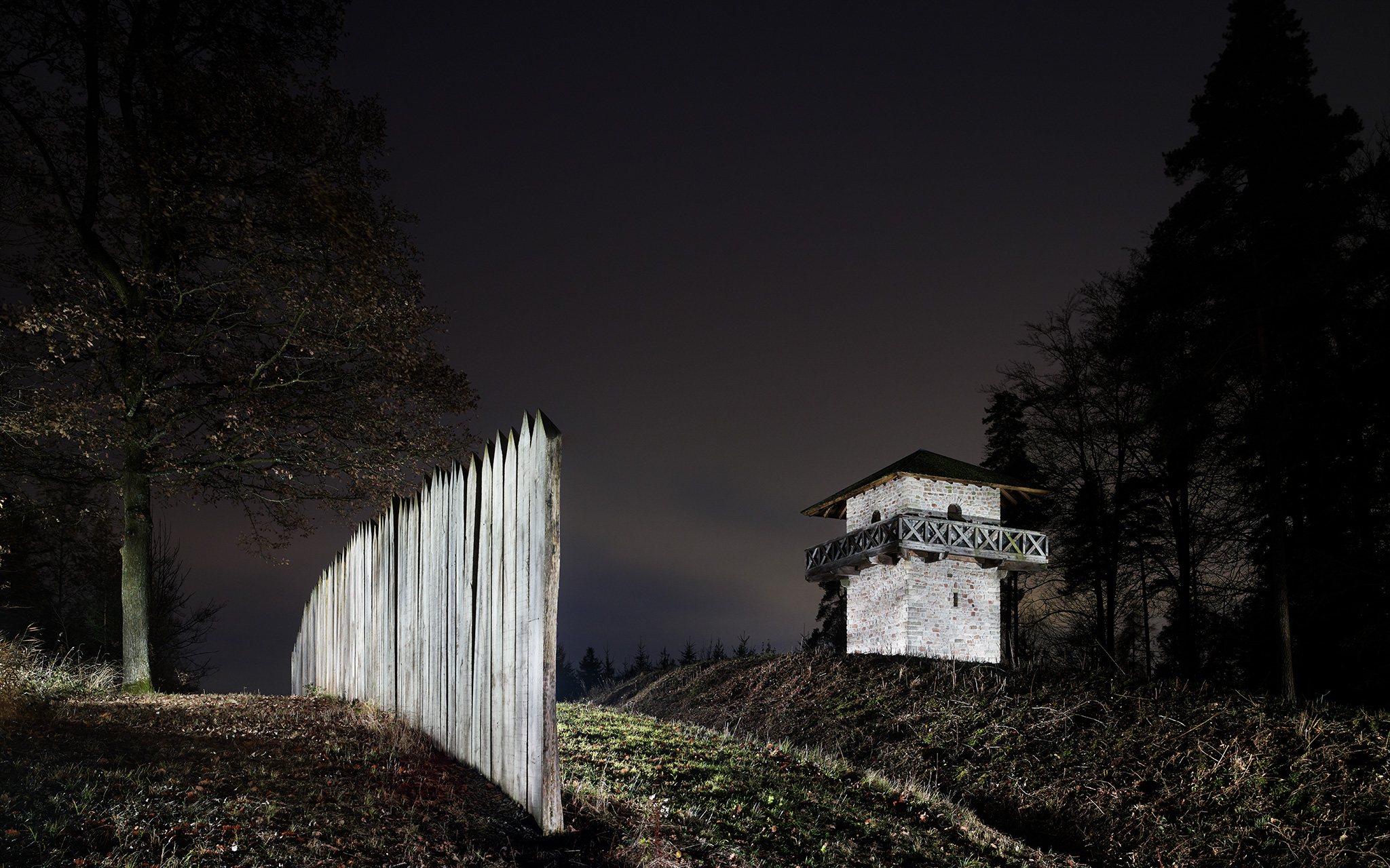
What did the border look like? Mounted soldiers controlled the border region along a cleared post path between watchtowers built in line of sight. Later, the border was reinforced with a continuous wooden palisade. Wooden posts were cut in half and aligned with the flat side facing Germania.
After about 50 years, the palisade fence was not renewed and was replaced from 160 AD by a system of ramparts and ditches. A ditch about 2 m deep was dug and a correspondingly high earth wall was heaped up. Behind it, the wooden towers were replaced by three-storey towers made of stone, plastered in white with joint lines painted in red and connected by the patrol road.
In the province of Raetia, on the other hand, a stone wall up to 3 m high replaced the wooden palisades. However, there were always regional peculiarities.
Along the Limes there were more than 100 smaller and larger forts where soldiers were stationed and which were often located at already existing road connections. The forts were easily accessible by roads for supplies. Goods were also transported to and from Germania on these roads. Border crossings were possible at Limes passages. All in all, the structure of the Limes is reminiscent of the organisation of today’s borders.
I am particularly interested in the traces of the Roman frontier in the landscape, such as the remains of ramparts and ditches still visible today along the Upper Germanic Limes in the Taunus and in the Swabian Forest, or the many inconspicuous hills along the frontier where a watchtower once stood.
I also photograph the reconstructions of the watchtowers and some forts – I find it interesting how differently research has interpreted the appearance of the Roman frontier over the years.
The work is not finished, but the pictures give a good impression of the traces of this almost 2000-year-old border.